Japan / Koshinetsu Region and Hokuriku Region /
JP103Mount Hakusan
Site Description
Forest
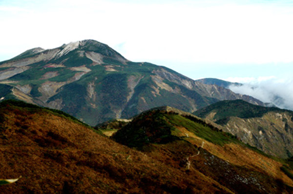
Mt. Hakusan is a volcanic mountain that extends over four prefectures of Toyama, Ishikawa, Fukui and Gifu. From the top of Mt. Hakusan to the climbers’ starting point to Hakusan, vegetation of the alpine belt, the subalpine belt and the Fagus crenata belt can be seen vertically. From the top of Hakusan, i.e. Gozenmine (2,702 m) to Midagahara (2,300 m) and Minamiryugababa extends the alpine belt. In this area the environment is harsh, and Pinus pumila belt, wind-blown slopes, snow patches and tall grasslands are scattered about. In the subalpine belt at a height of 2,300m high down to 1,500 m shrubs of Abies mariesii and others grow, and along steep slopes tall grasses and clumps of Sasa kurilensis are seen. In the area at a height of 1,500 m to 1,000 m near the starting point for climbers, there is a Fagus crenata belt that is characteristic of Hakusan and rich broadleaf deciduous forests are formed.
Area & Coordinates
119,000ha 36°09′N 136°46′E
region: Kohshinetsu Hokuriku
Category
A3
Designation Type
National Park, Wildlife Protection Area (government), Prefectural National Park
Protection Status
Protected
Conservation issues
- Abandonment/reduction of land management
- Recreation/tourism
- Construction/impact of dyke/dam/barrage)
- Consequences of animal/plants/ introductions
Birds
Breeding resident
Spizaetus nipalensis, Aquila chrysaetos, Strix uralensis, Picus awokera awokera, Dendrocopos major, Dendrocopos leucotos, Cinclus pallasii, Troglodytes troglodytes, Prunella collaris, Parus montanus, Parus ater
Breeding visitor
Cuculus fugax, Cuculus canorus, Cuculus saturatus, Otus scops, Halcyon coromanda, Prunella rubida, Luscinia cyane, Tarsiger cyanurus, Emberiza variabilis
Image
©SAKAI Teruo
![]()
